Sapporo — The City Japan Drew on a Blank Page
Sapporo
The Meaning
Most Japanese cities were never designed. They grew — outward from a castle or a crossroads, lane folding into lane over centuries, until even the locals navigate by landmarks rather than logic. That is why an address in Kyoto or Tokyo can take a taxi driver a moment to find, and why the streets curve for reasons no one alive remembers.
Sapporo is the exception. It was drawn.
In 1869, the new Meiji government renamed the northern island — once called Ezo — as Hokkaido, and set up an agency called the Kaitakushi, the Hokkaido Development Commission, to build and settle it. Their first act was to lay out a capital on the wide, flat Ishikari Plain, and they laid it out the way you would draw on a blank sheet of paper: a grid, running true north–south and east–west, blocks of about 109 meters marching off in every direction. They hired foreign advisors to help — among them the American agricultural commissioner Horace Capron — and built, in a few short decades, a modern city where there had been almost no town at all. So Sapporo feels different the moment you arrive: the streets are wide, the sky is open, the crowds thin out, and you can find any address by counting. Visitors often say it "doesn't feel like Japan." They are right, and now you know why. This is what Japan built the one time it started from a blank page and a ruler.
But the page was not actually blank. This plain was the homeland of the Ainu, the indigenous people of the north, long before the grid was drawn over it — the very name Sapporo comes from the Ainu language (one reading is sat-poro-pet, "a dry, great river"). The city's own records say it plainly: Hokkaido, where the Ainu lived, was where the Commission began its work in 1869. It is worth holding both facts at once — the ambition of the plan, and the land it was drawn upon.
There is one more thing the grid had to answer: the snow. The first flakes fall in late October, and by deep winter the city lives under roughly a meter of it, with five meters falling across a season. So this is not only a planned city; it is a city built to keep working through its winters — a place that answers its weather rather than merely enduring it. Hakodate, far to the south, shows you a Japan that opened to the world; Sapporo shows you a Japan that built — and on a clear night, from the mountain, you will see the whole plan laid out below you in light. We will climb to that last.
What Happens When You're There
Step 1: The Grid You Can Read
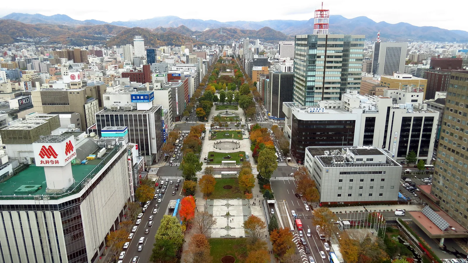
Begin in the middle, at Odori Park — the long green ribbon that runs east to west through the center of the city, about a kilometer and a half across twelve blocks. Most visitors take it for a pleasant downtown park, and in summer it is exactly that: lilac trees (the official tree of the city), fountains, the great Beer Garden, the YOSAKOI Soran dancers. In February it becomes the main stage of the Snow Festival. But look at how cleanly it divides the city, and you will see what it really is.
Odori was not first laid out as a park. In 1871 it was cut as a firebreak — a wide, deliberate gap to stop a fire on one side from leaping to the other. And the line it drew was not only against fire. To the north went the administrative district: the government offices, the courts, the seat of the Commission. To the south went the residences, the shops, and the pleasure quarter. Stand in the park and turn around once: face north toward the offices and the red brick of the old prefectural government, then south toward the department stores and the lights of Susukino. You are standing on the seam of a planned city — a single line that still tells the two halves apart, a century and a half later.
This is also where Sapporo's strangest, most useful trick reveals itself. Its addresses are coordinates. Odori is the zero line for north and south; a parallel axis runs the other way; and every address counts its distance from the center in blocks — "North 1, West 2," "South 4, West 3." Once it clicks, you can read the city like graph paper and walk straight to a place you have never been. Travelers who have spent a week getting lost in the older cities of the south arrive here and feel an odd relief. So do plenty of Japanese visitors. The grid that can feel a little cold at first is also the most legible city in the country.
At the eastern end of the park stands the Sapporo TV Tower, 147.2 meters tall, with an observation deck partway up. From there the grid runs away beneath you in a perfectly straight green line — the plan, seen from inside it.
Step 2: The Hall Everyone Calls a Letdown
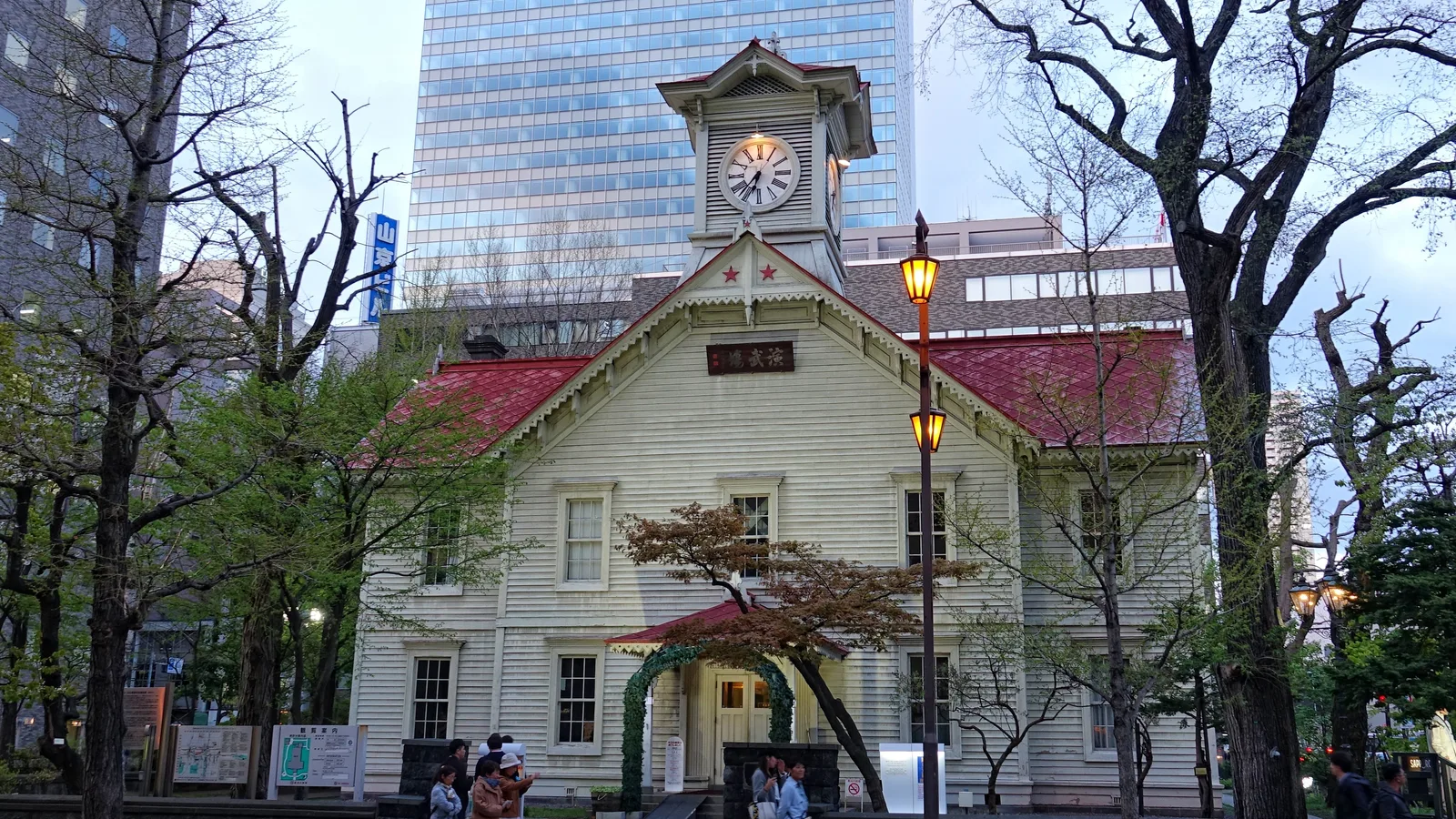
A block north of the park, hemmed in by office towers, is a small wooden building with a clock in its gable: the Sapporo Clock Tower. You should know its reputation before you see it, because the reputation is the point. Among Japanese travelers it is teased as one of the country's "three great disappointments" — a thing you photograph, realize is smaller than the postcard promised, and leave in five minutes. In 1878 it stood proud over a low frontier town; today it is a modest wooden hall swallowed by a grid of concrete, so the photo can never quite match the feeling. If you come expecting a monument, you will be let down — and you will be in excellent company, because the people most disappointed by it are Japanese.
But it disappoints only if you read it as a monument. It is not one. It was built in 1878 as the drill hall — the embujo — of the Sapporo Agricultural College, the school that is now Hokkaido University. The great clock in its tower came from the E. Howard company in Boston and began keeping time in 1881. This little building is not a sight bolted onto the city; it is one of the first things the city ever built, the seed crystal around which the whole planned capital grew.
There is a quiet way to see this for yourself. The Kaitakushi marked its work with a single emblem — a red five-pointed star, the Goryo Star, modeled on the North Star. Once you know it, you start finding it everywhere: on the Clock Tower (there are seventeen of them, if you care to count), on the old wooden Hoheikan, on the Seikatei, on the red brick of the former government office. Each star is a small signature left by the same hand that drew the grid. The Clock Tower is not a disappointing little building. It is the autograph at the bottom of the page.
Step 3: Boys, Be Ambitious
Walk toward the station and a little beyond it, and the grid opens into the broad, tree-lined campus of Hokkaido University. Its poplar and ginkgo avenues run as straight as the streets outside — the plan continued into a place of learning. This was the Sapporo Agricultural College, founded in 1876, which the university calls the first modern academic institute in Japan. It was not built to be beautiful. It was built to make the people who would build everything else: the engineers, the agronomists, the planners a frontier needs.
Its first vice-president was an American, William S. Clark, who came in 1876 with two professors and a handful of students, taught for less than a year, and left a single sentence behind. As he rode away at the parting, he is said to have called back to his students: "Boys, be ambitious!" The university keeps the phrase carefully — it notes that the longer versions often quoted today were embellished by later hands, and that these three words are the part that is real. They became, somehow, immortal in Japan. Stand under the poplars and you can feel why a country starting from nothing would want that sentence carved into its first school. The ambition is not a slogan here. It is the founding instruction.
Step 4: The Beer the Cold Made
South again, toward the entertainment district of Susukino and the old brewery quarter, and the lens reappears — this time on a plate, and in a glass. Sapporo is the birthplace of miso ramen, the rich, hot bowl a cold city invented for itself; it is the home of jingisukan, the grilled lamb that came out of the Commission's frontier ranching; and it gave its name to one of Japan's oldest beers. None of this is decoration. It is the frontier's table.
The beer is the clearest case. In 1875 the government had resolved to build its new brewery in Tokyo, and only move it north later if it succeeded. But the official in charge, Murahashi Hisanari, had listened to his German-trained brewer and understood something the planners in Tokyo had not: proper cold-fermented beer needs ice, and a cold climate to keep it. So he circulated a memo arguing that the brewery should be built in Hokkaido from the start, "given its ample snow and ice" — and the government changed its mind. The brewery opened in Sapporo in 1876, a Kaitakushi enterprise, and beer is still brewed on that ground today. It is a perfect small story of how this city works: not "the beer is famous, so drink it," but "the cold is the reason it is here at all." The weather chose the industry. (If you want to follow the wider geography of Japan's noodles, each broth belongs to its own region, and Sapporo's miso bowl is one of the clearest examples of a food a climate created.)
Step 5: The Plan, Lit
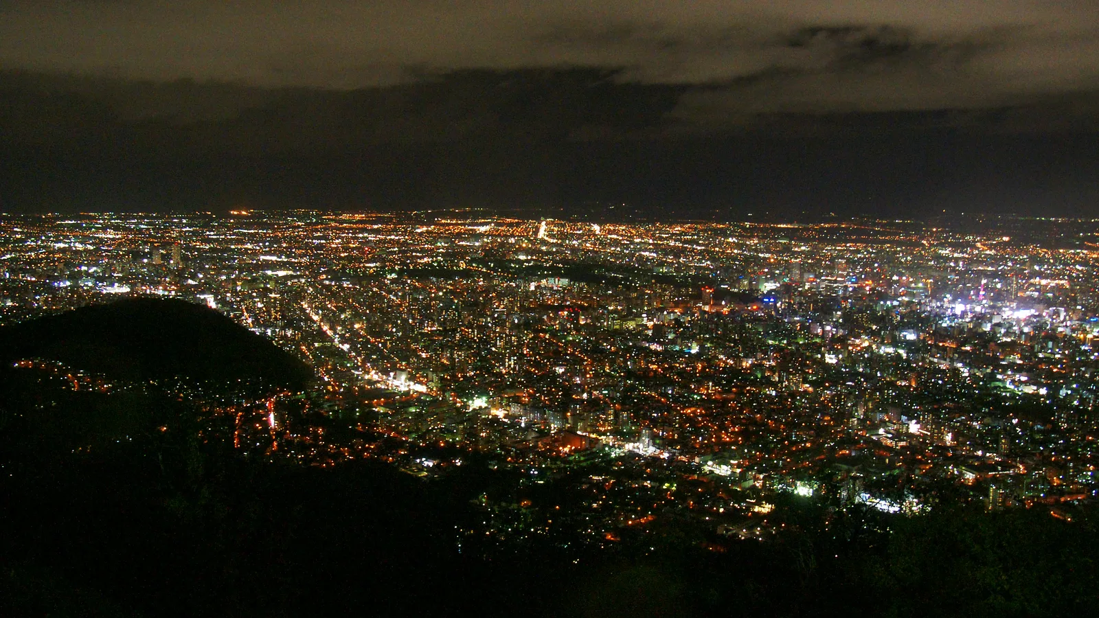
Save the last hour for the mountain. On the southwestern edge of the city, a ropeway and a small cable car carry you up Mount Moiwa to an observatory 531 meters high. Go at dusk, and wait for the light to come on below.
Most guides file it under "great night view" — and it is officially one of Japan's "New Three Major Night Views." But stand at the rail and look at what you are seeing. Hakodate's famous night view is the shape of the land itself, a glowing hourglass pinched by the sea. Sapporo's is something else entirely. Here the light falls into straight lines and right angles, running away to the dark edge of the Ishikari Plain — block after block after block, a grid of streetlamps and lit windows. The city's tourism office calls it "a carpet of jewels scattered across the plain." But look closer and it is more specific than jewels. It is the plan. The grid that was drawn on a blank page in 1869, the firebreak, the coordinates, the straight avenues of the college — all of it, finally switched on. You are not looking at a pretty accident of geography. You are looking at a decision, lit up. A city that someone sat down and drew, glowing in the snow.
Thank you for walking with us.
Good to Know
Getting there: you fly. This is the single thing to plan around. The bullet train does not yet reach Sapporo — the Hokkaido Shinkansen extension is still years away — so almost everyone arrives by air, at New Chitose Airport south of the city. From the airport, the JR Rapid "Airport" train runs straight to Sapporo Station in about 37 minutes, six times an hour through the middle of the day, with the platform connected directly to the terminal. Buy a ticket at the gate or tap an IC card (Kitaca, Suica, PASMO and the rest all work). If you are coming up from Hakodate instead, the Ltd. Express Hokuto links the two cities in about three and a half hours. Last verified: 2026-06. (For the wider logic of Japan's trains, passes and IC cards, see getting around Japan.)
Getting around town — and the city under the city. Sapporo's center is compact and walkable: Sapporo Station, Odori, and Susukino sit in a straight line about a kilometer apart. Under that line runs the Chi-Ka-Ho, the Sapporo Ekimae-dori Underground Walkway — opened in 2011, about 520 meters of heated, shop-lined concourse that lets you cross downtown in a blizzard without a coat. It is the clearest proof that this is a city built for its winters: barrier-free, open whatever the weather. Above ground, three subway lines (Namboku, Tozai and Toho) all meet at Odori Station, and a loop streetcar covers the southwest. Last verified: 2026-06.
How to read a Sapporo address. Worth thirty seconds, because it turns the city into a map you can solve. Addresses are coordinates: Odori Park is the line between North (kita) and South (minami), and a parallel axis splits East (higashi) from West (nishi). "North 1 West 2" means one block north of Odori and two blocks west of the center — and since the blocks are about 109 meters, you can estimate the walk before you start. The Clock Tower is North 1 West 2; remember that and you will never lose it.
How long, and what kind of trip. Sapporo is a livable, slow-burn city rather than a checklist of must-see sights, so give it the right amount of time and no more: two to three days for the city itself plus an easy trip or two, and it sings; rushed in an afternoon, it can feel like "just a city." The closest easy day trip is Otaru, a canal town about thirty to forty minutes away by train. But a common mistake is to base in Sapporo and try to day-trip the lavender hills of Furano and Biei, or Asahikawa — these are genuinely far, and deserve their own nights rather than a long round trip. Treat Sapporo as the hub of a wider Hokkaido loop and it earns its place.
When to go. There are really two Sapporos. Winter (the snow and the Sapporo Snow Festival, held about a week in early February — the 2027 edition runs February 4–11 — across the Odori, Susukino and Tsudome sites) is the famous one. Summer is the quiet secret: while the rest of Japan swelters, Sapporo stays cool and open, with lavender in the hills beyond, and it has long been the country's escape from the heat. The cherry blossoms come late this far north, around early May. The honest catch is the shoulder weather — winter days go dark by mid-afternoon, and the spring thaw is slushy for weeks — so pack for the season you choose. (More on choosing your season.)
The sights, with the practical details that change. Most of these reward an hour, not a pilgrimage:
- Sapporo Clock Tower — open 8:45–17:10 (closed Jan 1–3); adults ¥350, students and younger less or free.
- Sapporo TV Tower — observation deck open 9:00–22:00; adults ¥1,200.
- Former Hokkaido Government Office (the "Red Brick Office") — the grand 1888 brick building just north of Odori reopened in July 2025 after a long renovation, and is open again (roughly 8:45–21:00; small admission). Look for the red Goryo Star on its front.
- Sapporo Beer Museum — the only beer museum in Japan, on the grounds of the 1876 Kaitakushi brewery. Note that from July 2026 it charges admission (the self-guided visit was previously free), so check current hours and fees before you go.
- Mt. Moiwa Ropeway — to the night view: open from 10:30 (11:00 in winter) to 22:00, last ride up around 21:30; round trip about ¥2,100 for adults.
Because hours, fares and festival dates all shift, confirm anything time-sensitive on the official sites below before you build your day around it. Last verified: 2026-06.
What to wear, and the winter footing. Sapporo is colder than mainland Japan and snowy for nearly half the year. In winter the issue is less the cold than the ice underfoot — bring shoes with real grip, or pick up the rubber soles sold locally, and take the underground walkway when the wind is up. In summer a light layer is plenty; evenings on the mountain are cool in any season.
Official websites: Welcome to Sapporo (city tourism) · Sapporo Snow Festival · Mt. Moiwa Ropeway · Former Hokkaido Government Office
If Things Don't Go as Planned
The Clock Tower felt like a letdown. It is supposed to — that is practically its national reputation, and Japanese visitors feel it too. The trick is to stop looking for a monument and read it as the city's oldest signature: the 1878 drill hall of the college that started everything, marked with the Commission's star. Spend the five minutes, count a few stars, and walk on. The let-down is half the fun once you are in on the joke.
You rode up Mt. Moiwa and saw only cloud. The mountain makes its own weather, and a low evening can swallow the view. If a clear night is anywhere in your forecast, save the climb for it rather than spending your one good evening on a grey one — and if you are fogged out anyway, you are in the same boat as every local who has made the same gamble. The city is just as good at street level, lit from within.
Sapporo felt like "just a city." It can, for an afternoon — its rewards are atmosphere, food, and legibility rather than a row of headline sights. Slow down: read a few addresses by their coordinates, eat a bowl of miso ramen, walk the underground concourse, notice how the planned grid feels. The pleasure of Sapporo is understanding it, not ticking it off.
The addresses confused you. They confuse everyone for the first hour, then become the easiest in Japan. Find Odori (the north–south line) and the central axis (the east–west line), and read any address as "so many blocks from each." When in doubt, the subway and the underground walkway are all signed in English and meet at Odori.
The Beer Museum charges now, or was closed. As of July 2026 it became a paid facility, and it occasionally closes for upkeep, so check the official site rather than turning up cold. The Sapporo Beer Garden alongside it — for the lamb and the beer — keeps its own hours and is the part most people came for anyway.
It's deep winter and the day is disappearing by mid-afternoon. The far-north light is short, and the streets ice over. Build your day around it: sights and markets in the morning, the warm underground city in the afternoon, the night view bundled up after dark. Wear grippy shoes, slow your pace on the packed snow, and treat the long blue dusk as part of the experience rather than a problem.
You were going to day-trip Furano and Biei from Sapporo. Look hard at the train times first — the lavender hills are farther than the map suggests, and a same-day round trip eats most of the daylight in transit. If they matter to you, give them a night of their own. Save Sapporo's day trips for what is genuinely close, like Otaru.
Sources:
- City of Sapporo — About Sapporo / Outline and English Outline — Founding in 1869 under the Hokkaido Development Commission (Kaitakushi), Ezo renamed Hokkaido, the Ainu as the prior inhabitants of Hokkaido, the Ainu-language origin of the name "Sapporo" (the sat-poro-pet / "dry, great river" reading), first snow in late October and ~1 m / ~5 m snowfall, city status 1922, three subway lines
- Sapporo Tourist Association & City Cultural Properties Division — Cultural Heritage Walk: The Otomobori — The grid laid out by Iwamura Michitoshi, Odori as the administrative/residential divider, the ~109 m blocks, the Sosei River (formerly the Otomobori) as the east–west axis
- Sapporo Tourist Association — Cultural Heritage Walk: The Story of the Kaitakushi — The Kaitakushi (1869–1882) and its foreign advisors, the red Goryo Star emblem on the Clock Tower (17), Hoheikan and Seikatei, and Murahashi Hisanari's insistence on Sapporo for the brewery because cold-fermentation needed natural ice and a cool climate
- Odori Park Official (Sapporo Park & Greenery Association) — Odori Park 1.5 km, built in 1871 as a large-scale firebreak separating the northern administrative district from the southern residential/commercial district, 4,700 trees of 92 species, the TV Tower (147.2 m) and the park's festivals
- City of Sapporo — Sapporo Ekimae-dori Underground Walkway (Chi-Ka-Ho) — Opened 2011-03-12, links JR Sapporo Station to Susukino, built as a barrier-free, all-weather space "unaffected by season or weather"; ~520 m via Welcome to Sapporo
- Sapporo Clock Tower Official — Built 1878 as the drill hall (embujo) of the Sapporo Agricultural College (now Hokkaido University), the clock from E. Howard & Co. of Boston completed in 1881, Important Cultural Property (1970), hours 8:45–17:10, admission ¥350 (closed Jan 1–3), at North 1 West 2
- Sapporo TV Tower Official — Built 1957, 147.2 m, observation deck at 90.38 m, open 9:00–22:00, adult ¥1,200, eastern end of Odori Park
- Hokkaido University — History and Library: "Boys, be ambitious!" — Founded 1876 as Sapporo Agricultural College ("the first modern academic institute in Japan"), William S. Clark as first vice-president (arrived 1876 with Wheeler, Penhallow and students), the verified short form "Boys, be ambitious!" and the note that longer versions were later embellishments
- Sapporo Breweries Official — History (1876) — The 1875 plan to build the brewery in Tokyo, Murahashi Hisanari's memo arguing for Hokkaido "given its ample snow and ice" for low-temperature fermentation and aging, and the 1876 Kaitakushi brewery; Sapporo Beer Museum — Japan's only beer museum on the original brewery grounds, paid admission from July 2026
- Japan Tourism Agency Multilingual Database (content by City of Sapporo) — Sapporo Snow Festival and Sapporo Snow Festival Official — Begun in winter 1950 with six snow sculptures by students (~50,000 attended), JSDF assistance from 1955, the Odori/Susukino/Tsudome venues, more than two million visitors a year, and the next edition February 4–11, 2027
- Mt. Moiwa Ropeway Official and Welcome to Sapporo — Mt. Moiwa night view — The 531 m summit reached by ropeway and mini cable car, hours and round-trip fare (about ¥2,100), and the night view "like a carpet of jewels scattered across the Ishikari Plain," one of Japan's "New Three Major Night Views" (HOKKAIDO LOVE!)
- Hokkaido Prefectural Government — Former Hokkaido Government Office renewal and operator site — The red-brick building of 1888 (Important Cultural Property), reopened July 25, 2025 after seismic-retrofit renovation, and the red Goryo Star of the Development Commission on its facade
- JR Hokkaido — New Chitose Airport to Sapporo — The Rapid "Airport" train (about 37 minutes, six per hour through midday, IC cards accepted, platform connected to the terminal)
Image credits: Sapporo night view from Mt. Moiwa by 663highland (CC BY-SA 3.0); Odori Park by redlegsfan21 (CC BY-SA 2.0); Sapporo Clock Tower by Bjørn Christian Tørrissen (CC BY-SA 4.0) — all via Wikimedia Commons.
Were you there? Share your photos.
Your photo could appear in this guide — with your name and a link to your profile.
Submit a photo